Atkins Lake & Hiles Swamp
No. 238
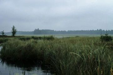
Photo by E. Epstein
Atkins Lake is a soft-water drainage lake lying within a vast conifer swamp (Hiles Swamp) on the Oneida/Forest county line. The lake is unusual in that the entire basin supports moderate to dense growths of emergents and floating-leaved aquatic vegetation including wild rice. Other aquatic macrophytes include pickerelweed, cat-tail, several pond weeds, and an abundance of water-shield, the inflorescence of which gives the lake a red color. These open communities are surrounded by the vast Hiles Swamp, a 1,700-acre complex of muskeg, a dense wet forest of black spruce and tamarack, a wet forest of tamarack alone, and an open bog.
Together the area forms perhaps one of the largest and most diverse northern wet forest communities on the Chequamegon-Nicolet. The swamp is home to several boreal plant and bird species uncommon in Wisconsin, including Carex tenuiflora, dragon's-mouth orchid, boreal chickadee, and gray jay. The surrounding uplands are forested with red and white pines, aspen, and balsam fir. Atkins Lake and Hiles Swamp are owned by the DNR and the U.S. Forest Service. It was designated a State Natural Area in 1990 and later expanded to include the USFS Hiles Swamp complex in 2007. This site is also recognized by the Forest Service as an established Research Natural Area.
Very few State Natural Areas have public facilities, but nearly all are open for a variety of recreational activities as indicated below. Generally, there are no picnic areas, restrooms, or other developments. Parking lots or designated parking areas are noted on individual SNA pages and maps. Trails, if present, are typically undesignated footpaths. If a developed trail is present, it will normally be noted on the SNA map under the Maps tab. A compass and topographic map or a GPS unit are useful tools for exploring larger, isolated SNAs.
The good majority of SNAs are isolated and have few or no facilities. Some SNAs have vehicle access lanes or parking lots, but their accessibility may vary depending on weather conditions. Parking lots and lanes are not plowed during winter. Hiking trails may be nonexistent or consist of undeveloped footpaths. A GPS unit or compass and a detailed topographic map are useful tools for exploring larger SNAs.
Hunting and trapping
This SNA has multiple landowners: Opportunities for hunting and trapping depend on the landowner. In general, most DNR-owned land allows hunting and trapping. Partner-owned land may have other rules (for example, university-owned lands do not allow hunting or trapping). Please contact them directly to find out about their rules for hunting and trapping. You can find a link to other owner websites under the Resources tab. More details regarding allowable uses of this non-DNR-owned SNA may be noted above and posted with signs on the property site.
Allowable activities: DNR-owned land
The activities listed below are generally allowed on all DNR-owned SNA lands. Exceptions to this list of public uses, such as SNAs closed to hunting, are noted above and posted with signs on the property site.
- Hiking
- Fishing
- Cross country skiing
- Hunting
- Trapping
- Scientific research (permit required)
- Outdoor education
- Wild edibles (What is this?)
- Pets (Rules)
- Wildlife viewing
Prohibited activities: all SNAs
- Camping and campfires
- Collecting of animals (other than legally harvested species), non-edible fungi, rocks, minerals, fossils, archaeological artifacts, soil, downed wood, or any other natural material, alive or dead.
- Collecting for scientific research requires a permit issued by the DNR
- Collecting of plants including seeds, roots or other non-edible parts of herbaceous plants such as wildflowers or grasses
- Geocaching
- Horseback riding
- Rock climbing
- Vehicles, including bicycles, ATVs, aircraft, and snowmobiles except on trails and roadways designated for their use.
For rules governing state-owned SNAs and other state lands, please consult Chapter NR 45 Wis. Admin. Code [exit DNR].
Location
Located (in part) within the Chequamegon-Nicolet National Forest. Forest & Oneida Counties. T37N-R11E, Sections 25, 36. T37N-R12E, Sections 7, 8, 17-20, 30, 13. 2,527 acres.
Driving directions
From the intersection of Yellow Birch Road (FR 2186) and Highway 32 in Hiles, go west on Yellow Birch Road for 0.85 miles, then southwest on Atkins Road (FR 2186) for about 3 miles, then west and south on FR 2861 1.4 miles. Walk west 0.1 miles to the lake.
The DNR's state natural areas program is comprised of lands owned by the state, private conservation organizations, municipalities, other governmental agencies, educational institutions and private individuals. While the majority of SNAs are open to the public, access may vary according to individual ownership policies. Public use restrictions may apply due to public safety, or to protect endangered or threatened species or unique natural features. Lands may be temporarily closed due to specific management activities.
Users are encouraged to contact the landowner for more specific details. The data shown on these maps have been obtained from various sources, and are of varying age, reliability, and resolution. The data may contain errors or omissions and should not be interpreted as a legal representation of legal ownership boundaries. To create your custom map where you can zoom to a specific location, please use the DNR's Mapping Application.
Atkins Lake & Hiles Swamp is owned by:
- US Forest Service
- Wisconsin DNR