Argonne Experimental Forest
No. 441
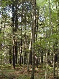
Photo by U.S. Forest Service
Argonne Experimental Forest features the largest contiguous tract of old-growth hemlock-hardwood forest on drumlinized ground moraine. These types of protected rich mesic hardwood forests are very scarce in northern Wisconsin and on this land type (Argonne Outwash Plains). Situated on a gently sloping, unpitted outwash fan is a northern mesic forest dominated by sugar maple, hemlock, yellow birch, and basswood. Sugar maple is reproducing best but basswood seedlings and white ash saplings are also present along with occasional ironwood poles.
The shrub layer is sparse with widely scattered leatherwood, and elderberry. Characteristic herbs include oak fern, ground pine, wood ferns, rosy twisted stalk, Canada mayflower, running club-moss, lady fern, and sweet cicely. Only minor amounts of downed logs, snags and tip-ups are present but numerous residual den trees (especially hemlock and yellow birch) add significantly to the stand structure. Also present are pole hardwoods that grade down into remnant hemlock-dominated forests with pockets of upland northern white cedar. This is surrounded by a good to excellent quality conifer swamp, which has several rare species.
The conifer swamp (northern wet forest) is dominated by black spruce, tamarack, and white cedar. Understory species include Labrador tea, leather-leaf, balsam fir, yellow bluebead lily, false mayflower, creeping snowberry, Canada blueberry, and sphagnum. Rare species include small round-leaved orchis, sparse-flowered sedges, and northern bog sedges. Several old raptor nests were located within the mesic forest.
The extensive habitat of Argonne Experimental Forest supports uncommon boreal bird species such as boreal chickadee and gray jay. In addition, the rare three-toed woodpecker (Picoides tridactylus) has been seen in the conifer swamp. Other birds include a broad-winged hawk, a blackburnian warbler, and scarlet tanager. Argonne Experimental Forest is owned by the US Forest Service and was designated a State Natural Area in 2007.
Very few State Natural Areas have public facilities, but nearly all are open for a variety of recreational activities as indicated below. Generally, there are no picnic areas, restrooms, or other developments. Parking lots or designated parking areas are noted on individual SNA pages and maps. Trails, if present, are typically undesignated footpaths. If a developed trail is present, it will normally be noted on the SNA map under the Maps tab. A compass and topographic map or a GPS unit are useful tools for exploring larger, isolated SNAs.
The good majority of SNAs are isolated and have few or no facilities. Some SNAs have vehicle access lanes or parking lots, but their accessibility may vary depending on weather conditions. Parking lots and lanes are not plowed during winter. Hiking trails may be nonexistent or consist of undeveloped footpaths. A GPS unit or compass and a detailed topographic map are useful tools for exploring larger SNAs.
Non-DNR lands
Entrance fees: For non-DNR-owned SNAs, we are unaware of any vehicle or admission fees. However, please contact the landowner for more information.
Hunting and trapping
Other activities
Other allowable activities such as - but not limited to camping, geocaching and bicycling are determined by the landowner. Please contact them directly or visit their websites for details.
Location
Located within the Chequamegon-Nicolet National Forest. Forest County. T38N-R12E, Sections 14, 22, 23, 26, 27, 28, 33. 1,125 acres.
Driving directions
From Hiles, go northwest on Highway 32 for 1.7 miles, then north on FR 2184 for about 2.6 miles. A portion of this site lies between FR 2184 and FR 3903. The northern portion can be accessed by continuing north on FR 2184, then east on FR 2183 for 1.4 miles. The site lies north and south of the road.
The DNR's state natural areas program is comprised of lands owned by the state, private conservation organizations, municipalities, other governmental agencies, educational institutions and private individuals. While the majority of SNAs are open to the public, access may vary according to individual ownership policies. Public use restrictions may apply due to public safety, or to protect endangered or threatened species or unique natural features. Lands may be temporarily closed due to specific management activities.
Users are encouraged to contact the landowner for more specific details. The data shown on these maps have been obtained from various sources, and are of varying age, reliability, and resolution. The data may contain errors or omissions and should not be interpreted as a legal representation of legal ownership boundaries. To create your custom map where you can zoom to a specific location, please use the DNR's Mapping Application.
Argonne Experimental Forest is owned by: US Forest Service