Apostle Islands Yew Forest
No. 639
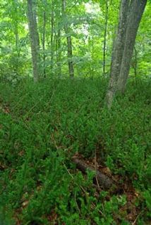
Photo by Thomas A. Meyer/DNR
The Apostle Islands Yew Forest SNA is comprised of four islands each containing a varying history of the deer population, management, and disturbance along with the accompanying effects on the forested vegetation. Located in far northwestern Wisconsin, Apostle Islands National Lakeshore is at the continental northwestern limits of the hemlock-white pine-northern hardwood forest and also contains elements of the boreal forest. In presettlement times, about 90% of the islands were covered by a mix of coniferous/hardwood forests dominated by hemlock, white pine, sugar maple, yellow birch, and paper birch.
Today, the forests reflect complex disturbance histories ranging from the pristine old-growth forest without a history of deer browsing, to forests subjected to logging, fires, and extensive deer browsing. After logging, deer populations were irrupted on many islands, severely impacting species favored by deer, such as Canada yew. This species has only minimally recovered on islands impacted by deer and may take hundreds of years to recover. In recent years, deer have become established on York Island and their numbers increased rapidly, decimating the yew understory.
At this time an intensive deer management strategy is taking place on York Island and Canada yew is re-establishing in the forest. In contrast, the entire Raspberry Island was set aside as a lighthouse reservation and escaped the extensive logging that took place on other islands. Raspberry Island has no evidence of a deer population and the forest still retains an abundance of Canada yew. The island's forest includes undisturbed northern mesic, northern wet-mesic forest, and an interior forest of virgin stands of white cedar and yellow birch with a tall shrub layer of mountain maple and yew. Balsam fir and paper birch dominate the island's shoreline.
On Cat Island, deer populations have been moderate through time and Canada yew is still dominant in the understory. Rocky Island supports a second-growth forest of yellow birch, white cedar, and balsam fir, and formerly contained a very high deer population. That population has now died out and the forest is beginning to recover from logging and deer browsing. The diversity of disturbance gradients and subsequent recovery of vegetation will provide important scientific data on the ecology of these four unique islands. Apostle Islands Yew Forest is owned by the US Park Service and was designated a State Natural Area in 2010.
Very few State Natural Areas have public facilities, but nearly all are open for a variety of recreational activities as indicated below. Generally, there are no picnic areas, restrooms, or other developments. Parking lots or designated parking areas are noted on individual SNA pages and maps. Trails, if present, are typically undesignated footpaths. If a developed trail is present, it will normally be noted on the SNA map under the Maps tab. A compass and topographic map or a GPS unit are useful tools for exploring larger, isolated SNAs.
The good majority of SNAs are isolated and have few or no facilities. Some SNAs have vehicle access lanes or parking lots, but their accessibility may vary depending on weather conditions. Parking lots and lanes are not plowed during winter. Hiking trails may be nonexistent or consist of undeveloped footpaths. A GPS unit or compass and a detailed topographic map are useful tools for exploring larger SNAs.
Non-DNR lands
Entrance fees: For non-DNR-owned SNAs, we are unaware of any vehicle or admission fees. However, please contact the landowner for more information.
Hunting and trapping
Other activities
Other allowable activities such as - but not limited to camping, geocaching and bicycling are determined by the landowner. Please contact them directly or visit their websites for details.
Location
Within the Apostle Islands National Lakeshore on Cat, Raspberry, Rocky, and York Islands. Ashland and Bayfield Counties. T52N-R2W, Sections 1, 2, 12. T52N-R3W, Sections 18, 19. T52N-R4W, Sections 9, 15, 16, 24. T53N-R2W, Sections 17-20, 25, 26, 35, 36. T53N-R3W, Sections 24, 25, 36. 2,842 acres.
Driving directions
The islands are accessible only by water. Shuttle service to the islands via private carrier can be arranged through the Apostle Islands National Lakeshore headquarters in Bayfield, off State Highway 13.
The DNR's state natural areas program is comprised of lands owned by the state, private conservation organizations, municipalities, other governmental agencies, educational institutions and private individuals. While the majority of SNAs are open to the public, access may vary according to individual ownership policies. Public use restrictions may apply due to public safety, or to protect endangered or threatened species or unique natural features. Lands may be temporarily closed due to specific management activities.
Users are encouraged to contact the landowner for more specific details. The data shown on these maps have been obtained from various sources, and are of varying age, reliability, and resolution. The data may contain errors or omissions and should not be interpreted as a legal representation of legal ownership boundaries. To create your custom map where you can zoom to a specific location, please use the DNR's Mapping Application.
Apostle Islands Yew Forest is owned by: National Park Service