Apostle Islands Maritime Forests
No. 266
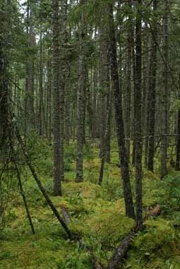
Photo by Thomas A. Meyer/DNR
Apostle Islands Maritime Forests consists of portions of five islands within the 21-island Apostle Islands archipelago. Soils on these sandstone-based islands vary from well-drained sands to poorly-drained clays, resulting in a variety of forest types. The cold waters of Lake Superior surrounding the islands greatly influence their vegetation. Except for Bear Island, deer are absent allowing hemlock and cedar to reproduce and Canada yew and other understory plants to thrive. The islands are owned and managed by the National Park Service. The Apostle Islands Maritime Forests were designated a State Natural Area in 1992.
Sand Island features a 167-acre northern wet-mesic forest with boreal affinities on the northeast tip of the island. A sparse canopy of huge (to 40 inches d.b.h.) white pine is mixed with yellow birch, red maple, white spruce, balsam fir, white cedar, and paper birch. This island supports the uncommon Chilean sweet cicely.
The 202-acre Outer Island unit features undisturbed old-growth northern mesic forest, clay bank seeps, and ephemeral ponds on the northern tip of the island. The virgin hemlock-hardwood forest here is perhaps the most significant single stand of its type in the Upper Great Lakes region. It is truly spectacular. Dominants are hemlock, up to 44” d.b.h and aged at an astonishing 400 years, along with yellow birch and lesser amounts of white cedar, sugar maple, balsam fir, white spruce and mountain ash. Supercanopy white pines provide nesting sites for bald eagles. The understory contains thick beds of yew, bluebead lilies, ferns, and clubmosses. A state-threatened plant is found on the moist clay banks along the shoreline
Bear Island’s 188-acre unit contains a large northern mesic forest, portions of which are recovering from past disturbance. The undisturbed portions are old-growth, containing large hemlocks (to 30” d.b.h.) and yellow birch, along with white cedar, sugar maple, red oak and basswood. A perched bog, with the northern wet and wet-mesic forest is also present.
Devils Island, the northernmost of the Apostles, features 263 acres of boreal-like northern mesic forest dominated by yellow birch, white cedar, and balsam fir. Associates include white pine, white spruce, paper birch, red maple, hemlock and balsam poplar. About 40 acres of boggy northern wet forest containing black spruce and tamarack are found in the interior. Merlins have been known to nest here.
Very few State Natural Areas have public facilities, but nearly all are open for a variety of recreational activities as indicated below. Generally, there are no picnic areas, restrooms, or other developments. Parking lots or designated parking areas are noted on individual SNA pages and maps. Trails, if present, are typically undesignated footpaths. If a developed trail is present, it will normally be noted on the SNA map under the Maps tab. A compass and topographic map or a GPS unit are useful tools for exploring larger, isolated SNAs.
The good majority of SNAs are isolated and have few or no facilities. Some SNAs have vehicle access lanes or parking lots, but their accessibility may vary depending on weather conditions. Parking lots and lanes are not plowed during winter. Hiking trails may be nonexistent or consist of undeveloped footpaths. A GPS unit or compass and a detailed topographic map are useful tools for exploring larger SNAs.
Non-DNR lands
Entrance fees: For non-DNR-owned SNAs, we are unaware of any vehicle or admission fees. However, please contact the landowner for more information.
Hunting and trapping
Other activities
Other allowable activities such as - but not limited to camping, geocaching and bicycling are determined by the landowner. Please contact them directly or visit their websites for details.
Location
Within the Apostle Islands National Lakeshore on Stockton, Sand, Oak, Outer, North Twin, Bear, and Devils Islands, Ashland and Bayfield Counties. T52N-R1W, Sections 17, 19, 20, 29, 30, 31 (Stockton). T52N-5W, Sections 12, 13, 23, 24 (Sand Island). T52N-R3W, Sections 16, 21, 22 (Oak). T52N-R3W, Sections 18, 19; T53N-R1W, Section 13 (Outer Island). T53N-R2W, Sections 14, 15, 22, 23 (North Twin). T53N-R3W, Section 33; T52N-R3W, Section 4 (Bear Island). T53N-R3W, Sections 10, 15 (Devils Island). 6,409 acres.
Driving directions
Islands are accessible only by water. Shuttle service to the islands via private carrier can be arranged through the Apostle Islands National Lakeshore headquarters in Bayfield, off State Highway 13. Entrance to the Devils Island unit requires the permission of private landowners to use their docks.
The DNR's state natural areas program is comprised of lands owned by the state, private conservation organizations, municipalities, other governmental agencies, educational institutions and private individuals. While the majority of SNAs are open to the public, access may vary according to individual ownership policies. Public use restrictions may apply due to public safety, or to protect endangered or threatened species or unique natural features. Lands may be temporarily closed due to specific management activities.
Users are encouraged to contact the landowner for more specific details. The data shown on these maps have been obtained from various sources, and are of varying age, reliability, and resolution. The data may contain errors or omissions and should not be interpreted as a legal representation of legal ownership boundaries. To create your custom map where you can zoom to a specific location, please use the DNR's Mapping Application.
Apostle Islands Maritime Forests is owned by: National Park Service