Apostle Islands Maritime Cliffs
No. 267
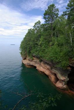
Photo by Thomas A. Meyer/DNR
Two Lake Superior islands -- Otter and Devils -- within the Apostle Islands archipelago and an area of the mainland in Bayfield County all contain units of this State Natural Area. These unique sites feature exposed sandstone cliffs, sea caves, vaulted chambers, arches, and pillars. Lake Superior waves, along with wind and ice, have sculpted these features from the erodible, reddish-brown Precambrian sandstone of the Devil's Island Formation, which originated 500 million years ago as river-deposited sands.
On Otter Island, the natural area consists of about 1 mile of cliffs on the north end of the island. Rare plants find refuge on the semi-shaded, dripping sandstone cliff faces and bluff edges. The cliffs on the north end of Devils Island are similar, and also harbor rare plants. These and two other Apostle Island sites are the only known locations for one of the state's rare plant species. At Mawikwe Bay Cliffs, a forest of red pine, white pine, paper birch, white cedar and balsam fir grows above the cliffs. The Apostle Islands Maritime Cliffs are owned by the National Park Service and were designated a State Natural Area in 1992.
Location
Within the Apostle Islands National Lakeshore. Otter Island and Devils Island, Ashland County. T52N-R3W, Sections 1, 2 (Otter Island). T53N-R3W, Section 10 (Devils Island). Mawikwe Bay Cliffs, Bayfield County. T51N-R5W, Sections 8, 9, 17, 18 (Mainland). 152 Acres.
Driving directions
The island units are accessible only by water. Shuttle service to the islands via private carrier can be arranged through the Apostle Islands National Lakeshore headquarters in Bayfield, off State Highway 13. Entrance to the Devils Island unit requires the permission of private landowners to use their docks. The Mawikwe Bay Cliffs unit is on the mainland and accessible by both land and water. From the junction of Highways C and 13 in Cornucopia, go 4.3 miles northeast on 13 to Meyers Rd., then 0.4 miles north to the Meyer's Beach parking lot and the trailhead for the Lakeshore Trail. Walk northeast along the trail 1.2 miles to the cliffs.
The cliffs and sea caves are accessible by watercraft via the carry-in canoe launch at Meyer's Beach. Paddle northeast along the shore 1.2 miles to the beginning of the cliffs. The cliffs extend for more than 2 miles. In cold winters when the lake is sufficiently frozen, the cliffs may be reached by walking over the ice. Check the website of the Apostle Islands National Lakeshore for a status report on the lake's ice conditions.
The DNR's state natural areas program is comprised of lands owned by the state, private conservation organizations, municipalities, other governmental agencies, educational institutions and private individuals. While the majority of SNAs are open to the public, access may vary according to individual ownership policies. Public use restrictions may apply due to public safety, or to protect endangered or threatened species or unique natural features. Lands may be temporarily closed due to specific management activities.
Users are encouraged to contact the landowner for more specific details. The data shown on these maps have been obtained from various sources, and are of varying age, reliability, and resolution. The data may contain errors or omissions and should not be interpreted as a legal representation of legal ownership boundaries. To create your custom map where you can zoom to a specific location, please use the DNR's Mapping Application.
Apostle Islands Maritime Cliffs is owned by: National Park Service