Ancient Aztalan Village
No. 408
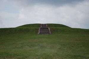
Photo by Joshua Mayer
Ancient Aztalan Village is a unique, archaeological treasure of Native American culture and is one of the most important archaeological sites in Wisconsin. Aztalan showcases an ancient Middle Mississippian village and ceremonial complex that flourished between 1000 and 1200 AD. It is one of the northernmost outposts of the Middle Mississippian Tradition. This tradition is most notable in west-central Illinois at a site called Cahokia.
Mound and stockade construction, house construction, pottery decoration and agricultural practices are just a few of the similarities that exist between Aztalan and Cahokia. But there are differences. Although classic Middle Mississippian features exist, many artifacts belonging to the local Woodland people are also present in large numbers.
The people who settled in Aztalan built large, flat-topped pyramidal mounds and a stockade around their village. They hunted, fished and farmed on the floodplain of the Crawfish River. It is believed that the Aztalan Indians moved north to Wisconsin from the large mound settlement at Cahokia near St. Louis, Illinois. Following the Mississippi, Rock and Crawfish rivers they finally settled on the west bank of the Crawfish River near Lake Mills.
The village prospered until 1200 AD, after which all the inhabitants left. The reason for this abandonment remains a mystery. Aztalan become a state park in 1948. The site was designated a National Landmark in 1964 and listed in the National Registry of Historic Places in 1966. Ancient Aztalan Village is owned by the DNR and was designated a State Natural Area in 2003.
Very few State Natural Areas have public facilities, but nearly all are open for a variety of recreational activities as indicated below. Generally, there are no picnic areas, restrooms, or other developments. Parking lots or designated parking areas are noted on individual SNA pages and maps. Trails, if present, are typically undesignated footpaths. If a developed trail is present, it will normally be noted on the SNA map under the Maps tab. A compass and topographic map or a GPS unit are useful tools for exploring larger, isolated SNAs.
The good majority of SNAs are isolated and have few or no facilities. Some SNAs have vehicle access lanes or parking lots, but their accessibility may vary depending on weather conditions. Parking lots and lanes are not plowed during winter. Hiking trails may be nonexistent or consist of undeveloped footpaths. A GPS unit or compass and a detailed topographic map are useful tools for exploring larger SNAs.
Entrance fees: Excepting Parfrey's Glen, the Cambrian Outlook in the Dells of the Wisconsin River, SNAs within State Parks and some within State Forests, all other DNR-owned SNAs do not have any admission fees.
Allowable activities: DNR-owned land
The activities listed below are generally allowed on all DNR-owned SNA lands. Exceptions to this list of public uses, such as SNAs closed to hunting, are noted above and posted with signs on the property site.
- Hiking
- Fishing
- Cross country skiing
- Hunting
- Trapping
- Scientific research (permit required)
- Outdoor education
- Wild edibles (What is this?)
- Pets (Rules)
- Wildlife viewing
Prohibited activities: all SNAs
- Camping and campfires
- Collecting of animals (other than legally harvested species), non-edible fungi, rocks, minerals, fossils, archaeological artifacts, soil, downed wood, or any other natural material, alive or dead.
- Collecting for scientific research requires a permit issued by the DNR
- Collecting of plants including seeds, roots or other non-edible parts of herbaceous plants such as wildflowers or grasses
- Geocaching
- Horseback riding
- Rock climbing
- Vehicles, including bicycles, ATVs, aircraft, and snowmobiles except on trails and roadways designated for their use.
For rules governing state-owned SNAs and other state lands, please consult Chapter NR 45 Wis. Admin. Code [exit DNR].
Location
Within Aztalan State Park, Jefferson County. 25 Acres.
Driving directions
From the intersection of I-94 and State Highway 89 in Lake Mills, go south on 89 for 0.9 miles, then west on County B for 2.6 miles, then south on County Q about 0.4 miles to the park entrance. The park is open year-round from 6 a.m. to 10 p.m.
The DNR's state natural areas program is comprised of lands owned by the state, private conservation organizations, municipalities, other governmental agencies, educational institutions and private individuals. While the majority of SNAs are open to the public, access may vary according to individual ownership policies. Public use restrictions may apply due to public safety, or to protect endangered or threatened species or unique natural features. Lands may be temporarily closed due to specific management activities.
Users are encouraged to contact the landowner for more specific details. The data shown on these maps have been obtained from various sources, and are of varying age, reliability, and resolution. The data may contain errors or omissions and should not be interpreted as a legal representation of legal ownership boundaries. To create your custom map where you can zoom to a specific location, please use the DNR's Mapping Application.
Ancient Aztalan Village is owned by: Wisconsin DNR