Alvin Creek Headwaters
No. 443
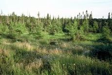
Photo by U.S. Forest Service
The Alvin Creek complex presents an excellent opportunity to protect a unique assemblage of high-quality biological communities and glacial landforms. At the heart of the complex are the Alvin Creek headwaters wetlands, a unique area of springs and ponds, bogs and sedge meadows, alder thickets, and lowland forests of various types. Alvin Creek, part of the Brule River watershed, begins as the outlet of a seven-acre spring pond, flows into a small drainage lake, thence between drumlin ridges where the stream is mostly alder-lined and alternately associated with wet forests of black spruce/tamarack, white-cedar, and black ash. The areas surrounding the spring pond and lake are for the most part open and very wet and support a rich and unusual patchwork of bog, sedge meadow, and marsh species that defies formal community classification.
Several rare and/or uncommon plant species occur here. The surrounding uplands are forested mainly with hemlock-hardwood mixes, but also include some rich hardwoods and a small but excellent stand of old-growth hemlock under numerous super-canopy white pine. Upland stands on adjacent State Trust lands include minimally disturbed old-growth. Adjacent old-growth stands on National Forest lands are restricted to narrow zones on steep slopes bordering wetlands and are dominated by hemlock. Hemlock up to 30 inches in diameter is common in the best stands, mixed with sugar maple and yellow birch of comparable size. White pine forms a super-canopy in many of the older stands. Understories are generally quite open in the older stands, though sugar maple saplings are dense in a few places. The shrub layer is poorly developed, while the ground layer varies from dense and diverse to rather sparse and species-poor, depending on soil and stand type.
Intermediate wood fern, oak fern, maidenhair fern, lady fern, rosy twisted stalk, club-mosses, Canada mayflower, and American starflower are common ground-layer species. Alvin Creek and its tributary have a history of beaver activity and the most recent flooding, in the 1980s, resulted in the killing of many lowland forest stands, including stands of white cedar and black ash. As evidenced by the numerous standing dead trees, flooding occurred along nearly the entire length of those portions of the creeks within the complex, including the headwaters spring pond area. The open bog surrounding the spring pond suffered no lasting ill effects, as the rare plant populations are still present. Alvin Creek Headwaters is owned by the US Forest Service and was designated a State Natural Area in 2007.
Very few State Natural Areas have public facilities, but nearly all are open for a variety of recreational activities as indicated below. Generally, there are no picnic areas, restrooms, or other developments. Parking lots or designated parking areas are noted on individual SNA pages and maps. Trails, if present, are typically undesignated footpaths. If a developed trail is present, it will normally be noted on the SNA map under the Maps tab. A compass and topographic map or a GPS unit are useful tools for exploring larger, isolated SNAs.
The good majority of SNAs are isolated and have few or no facilities. Some SNAs have vehicle access lanes or parking lots, but their accessibility may vary depending on weather conditions. Parking lots and lanes are not plowed during winter. Hiking trails may be nonexistent or consist of undeveloped footpaths. A GPS unit or compass and a detailed topographic map are useful tools for exploring larger SNAs.
Non-DNR lands
Entrance fees: For non-DNR-owned SNAs, we are unaware of any vehicle or admission fees. However, please contact the landowner for more information.
Hunting and trapping
Other activities
Other allowable activities such as - but not limited to camping, geocaching and bicycling are determined by the landowner. Please contact them directly or visit their websites for details.
Location
Located within the Chequamegon-Nicolet National Forest. Forest County. T40N-R13E Sections 10, 11,15, 16, 21, 22. 1,048 acres.
Driving directions
The site is approximately 20 miles east of Eagle River on STH 70. Highway 70 forms the north boundary of the site. FR 2175, 2243, and 2427 provide further access.
The DNR's state natural areas program is comprised of lands owned by the state, private conservation organizations, municipalities, other governmental agencies, educational institutions and private individuals. While the majority of SNAs are open to the public, access may vary according to individual ownership policies. Public use restrictions may apply due to public safety, or to protect endangered or threatened species or unique natural features. Lands may be temporarily closed due to specific management activities.
Users are encouraged to contact the landowner for more specific details. The data shown on these maps have been obtained from various sources, and are of varying age, reliability, and resolution. The data may contain errors or omissions and should not be interpreted as a legal representation of legal ownership boundaries. To create your custom map where you can zoom to a specific location, please use the DNR's Mapping Application.
Alvin Creek Headwaters is owned by: US Forest Service