Allen Creek Wetlands
No. 641
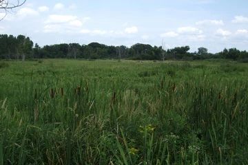
Photo by Groundswell Conservancy
Allen Creek Wetlands is a wetland complex of sedge meadow and wet-mesic prairie with pockets of calcareous fen. The wetlands support a diverse flora that includes blue-joint grass, big bluestem, marsh skullcap, marsh marigold, bulblet water-hemlock, water horehound, prairie blazing star, valerian, fringed brome, swamp lousewort, mountain mint. The complex is drained by Allen Creek, an Exceptional Resource Water (ERW) that contains the least darter, a species of special concern. Exceptional Resource Waters are surface waters that provide outstanding recreational opportunities, support valuable fisheries and wildlife habitat, have good water quality and are not significantly impacted by human activities. Local landowners have formed Friends of Allen Creek Watershed - an organization dedicated to the study, protection, and preservation of Allen Creek and its watershed. The highest quality areas, while privately owned, are actively managed by the landowners and volunteers through prescribed burns and brush removal. This portion of the SNA is only accessible to the public through field trips hosted by The Prairie Enthusiasts. Allen Creek Wetlands is owned by the DNR and private landowners. It was designated a State Natural Area in 2010.
Very few State Natural Areas have public facilities, but nearly all are open for a variety of recreational activities as indicated below. Generally, there are no picnic areas, restrooms, or other developments. Parking lots or designated parking areas are noted on individual SNA pages and maps. Trails, if present, are typically undesignated footpaths. If a developed trail is present, it will normally be noted on the SNA map under the Maps tab. A compass and topographic map or a GPS unit are useful tools for exploring larger, isolated SNAs.
The good majority of SNAs are isolated and have few or no facilities. Some SNAs have vehicle access lanes or parking lots, but their accessibility may vary depending on weather conditions. Parking lots and lanes are not plowed during winter. Hiking trails may be nonexistent or consist of undeveloped footpaths. A GPS unit or compass and a detailed topographic map are useful tools for exploring larger SNAs.
Hunting and trapping
Allowable activities: DNR-owned land
The activities listed below are generally allowed on all DNR-owned SNA lands. Exceptions to this list of public uses, such as SNAs closed to hunting, are noted above and posted with signs on the property site.
- Hiking
- Fishing
- Cross country skiing
- Hunting
- Trapping
- Scientific research (permit required)
- Outdoor education
- Wild edibles (What is this?)
- Pets (Rules)
- Wildlife viewing
Prohibited activities: all SNAs
- Camping and campfires
- Collecting of animals (other than legally harvested species), non-edible fungi, rocks, minerals, fossils, archaeological artifacts, soil, downed wood, or any other natural material, alive or dead.
- Collecting for scientific research requires a permit issued by the DNR
- Collecting of plants including seeds, roots or other non-edible parts of herbaceous plants such as wildflowers or grasses
- Geocaching
- Horseback riding
- Rock climbing
- Vehicles, including bicycles, ATVs, aircraft, and snowmobiles except on trails and roadways designated for their use.
For rules governing state-owned SNAs and other state lands, please consult Chapter NR 45 Wis. Admin. Code [exit DNR].
Location
Jefferson County. T5N-R14E, Sections 21, 22. 33 acres.
Driving directions
From the intersection of Highway 12 and State 106 in Fort Atkinson, go east on 12 for 1.75 miles, then south on County K for 1.8 miles, then west on Star School Road for 0.4 miles. Walk south into the site.
The DNR's state natural areas program is comprised of lands owned by the state, private conservation organizations, municipalities, other governmental agencies, educational institutions and private individuals. While the majority of SNAs are open to the public, access may vary according to individual ownership policies. Public use restrictions may apply due to public safety, or to protect endangered or threatened species or unique natural features. Lands may be temporarily closed due to specific management activities.
Users are encouraged to contact the landowner for more specific details. The data shown on these maps have been obtained from various sources, and are of varying age, reliability, and resolution. The data may contain errors or omissions and should not be interpreted as a legal representation of legal ownership boundaries. To create your custom map where you can zoom to a specific location, please use the DNR's Mapping Application.
Allen Creek Wetlands is owned by: Private and Wisconsin DNR