Ableman's Gorge
No. 75
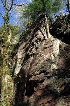
Ableman's Gorge is a classic gorge cut by the Baraboo River through Baraboo quartzite, Cambrian sandstone, and conglomerate. The cliffs and rocky slopes rise about 200 feet above the river to form a wall nearly three-fourths of a mile long, oriented east-west, which then abruptly turns south for a similar distance. The latter portion is 250-450 feet wide and is composed of irregular quartzite cliffs. Spectacular unconformable contact with younger Cambrian sandstone can be seen on both the north and south sides of the Precambrian Baraboo quartzite. The exposures of the unconformity between the ancient quartzite and the overlying sandstone are world-famous. The site tells a fascinating geological story of changing conditions in an ancient sea that first rose quietly against a cliff of quartzite and then, as layers of sediments gradually decreased the relief between the sea floor and land, surged against the top of the cliff, wearing away quartzite and depositing a layer of cobbles and boulders across its upturned edge. Erosional forces and a former quarrying operation in the southern part of the natural area have re-exposed these long-buried layers. Nowhere in the Midwest is such a sequence of events so displayed.
The cool, moist, north-facing slopes shelter plants more typical of northern Wisconsin, including hemlock, yellow birch, mountain maple and Canada yew. The ground layer contains numerous ferns and includes species such as Virginia water-leaf and Canada mayflower. The area is widely used for geology research and a plaque honors researcher Charles Van Hise, who formulated some of his principles of structural deformation and metamorphism here. Ableman's Gorge is owned by the DNR and the University of Wisconsin and was designated a State Natural Area in 1969.
Very few State Natural Areas have public facilities, but nearly all are open for a variety of recreational activities as indicated below. Generally, there are no picnic areas, restrooms, or other developments. Parking lots or designated parking areas are noted on individual SNA pages and maps. Trails, if present, are typically undesignated footpaths. If a developed trail is present, it will normally be noted on the SNA map. A compass and topographic map or a GPS unit are useful tools for exploring larger, isolated SNAs.
The good majority of SNAs are isolated and have few or no facilities. Some SNAs have vehicle access lanes or parking lots, but their accessibility may vary depending on weather conditions. Parking lots and lanes are not plowed during winter. Hiking trails may be nonexistent or consist of undeveloped footpaths. A GPS unit or compass and a detailed topographic map are useful tools for exploring larger SNAs.
Hunting and trapping
This SNA has multiple landowners: Opportunities for hunting and trapping depend on the landowner. In general, most DNR-owned land allows hunting and trapping. Partner-owned land may have other rules (for example, university-owned lands do not allow hunting or trapping). Please contact them directly to find out about their rules for hunting and trapping. You can find a link to other owner websites under the Resources tab.
NOTE: Per state regulations, hunting is allowed on the DNR-owned SNA lands. However, on lands located within the Village of Rock Springs (see map), the discharge of firearms is prohibited within the village limits. See their Village Ordinance Chapter 4 [exit DNR] for details.
Allowable activities: DNR-owned land
The activities listed below are generally allowed on all DNR-owned SNA lands. Exceptions to this list of public uses, such as SNAs closed to hunting, are noted below and posted with signs on site.
- Hiking
- Fishing
- Cross country skiing
- Hunting
- Trapping
- Scientific research (permit required)
- Outdoor education
- Wild edibles (What is this?)
- Pets (Rules)
- Wildlife viewing
Prohibited activities: all SNAs
- Camping and campfires
- Collecting of animals (other than legally harvested species), non-edible fungi, rocks, minerals, fossils, archaeological artifacts, soil, downed wood, or any other natural material, alive or dead.
- Collecting for scientific research requires a permit issued by the DNR
- Collecting of plants including seeds, roots or other non-edible parts of herbaceous plants such as wildflowers or grasses
- Geocaching
- Horseback riding
- Rock climbing
- Vehicles, including bicycles, ATVs, aircraft, and snowmobiles except on trails and roadways designated for their use.
For rules governing state-owned SNAs and other state lands, please consult Chapter NR 45 Wis. Admin. Code [exit DNR].
Location
Sauk County. T12N-R5E, Sections 28, 29. 127 acres.
Driving directions
From the intersection of State Highways 136 and 154 in Rock Springs, go west on Highway 136 one mile to a parking area on the left just before the Baraboo River bridge. Direct access to the quarry's exposed rock is afforded by parking in the pull-off on the east side of Highway 136 across from the bottling plant and then crossing the highway to the DNR gate north of the plant. A trail begins there and leads to Van Hise Rock.
The DNR's state natural areas program is comprised of lands owned by the state, private conservation organizations, municipalities, other governmental agencies, educational institutions and private individuals. While the majority of SNAs are open to the public, access may vary according to individual ownership policies. Public use restrictions may apply due to public safety, or to protect endangered or threatened species or unique natural features. Lands may be temporarily closed due to specific management activities.
Users are encouraged to contact the landowner for more specific details. The data shown on these maps have been obtained from various sources, and are of varying age, reliability, and resolution. The data may contain errors or omissions and should not be interpreted as a legal representation of legal ownership boundaries. To create your custom map where you can zoom to a specific location, please use the DNR's Mapping Application.
Ableman's Gorge is owned by:
- UW Board of Regents
- Wisconsin DNR