Rush Lake Restoration
History
The past 30 years witnessed a dramatic decline in the lake's aquatic vegetation, water quality and wildlife populations. Research has attributed these declines to artificially stable and high water levels, carp infestation and nutrient/sediment runoff. View a comparison of Rush Lake in 1937 and 2005 [PDF].
In order to tackle these problems and formulate a Lake restoration plan, a steering committee was formed in 1999 including government representatives, citizens, and user groups. The 15-member committee conducted monthly meetings from 1999-2005 and completed an extensive citizen involvement process. The group developed a plan that addressed all the significant problems facing the lake and had strong public support garnered through citizen participation. This plan is now being implemented as part of a holistic lake restoration project.
Public access
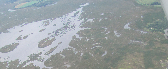
There are three public access points to Rush Lake. These include two gravel boat landings and one walk in access. Please be aware that the average depth of Rush Lake is 1.5 feet deep and boating is suitable only for canoes, skiffs, kayaks and small boats powered by marsh type "go-devil" engines. The bottom of Rush Lake consists of deep muck and extreme care should be used when walking on the bottom.
- South landing: This gravel boat landing is located at the end of Lake Road in Ripon Township, Fond du Lac County. From Ripon take County Road E north two miles to Cork Street, turn right heading east on Cork Street 1.2 miles to Lake Road, turn left on Lake Road heading north one mile to the landing.
- East landing: This gravel boat landing is located off of County Road M in Nepeuskun Township, Winnebago County. From Pickett take County Road M north five miles and turn left just before Waukau Creek Crosses the highway. Drive over the bridge and follow the gravel road down to the Lake. Please park in the gravel parking lots provided. There is additional parking across the street in the U.S. Fish and Wildlife Service lot.
- North access: This walk in access is located off of Osborne Road in Nepeuskun Township, Winnebago County. From Pickett take County Road M six miles north to Osborne Road. Turn left on Osborne heading west, go 0.75 miles and turn left (south) into the DNR parking area and walk in access point. This area provides walk in access to the Lake. Be advised that there are over 300 yards of cattail marsh that must be traversed before reaching open water.
Please treat these areas with respect and take out all litter, stay on gravel roads and report all vandalism. Public lands are your lands!
Facts
- Rush Lake is called a "prairie pothole lake" because it is similar to the prairie wetlands of North America that produce so many of our waterfowl.
- The unique vegetation of the prairie potholes is a product of periodic droughts and water level fluctuations that allow aquatic vegetation the opportunity to become established and sustained.
- Historical records and archeological evidence indicate Native Americans found the Rush Lake area a good place to hunt and gather food.
- This 3,070-acre lake is less than two feet deep except for several small spots that are three to five feet deep.
- About 1%, or 33 acres of the lake, has a hard bottom. The remainder is soft muck, in places over 20 feet deep.
- During severe droughts, probably including the "dust bowl" years, people have hunted rabbits on the dried-up and caked lake bed.
- Surveys completed in 1994 found about 361,000 lead shot per acre of Rush Lake bottom or 8.3 shot per square foot!
- The equivalent of 1,284 shells per acre of lake bottom means that over 3,852,000 shells have been fired over Rush Lake!
- 3,852,000 shotshells is the equivalent of about 150 Tons of lead shot!
- Rush Lake is home to several species unique to Wisconsin, including the red-necked grebe and Forster's tern.
- The last major die-off of waterfowl on Rush Lake due to lead poisoning was in 1989. Over 1,270 birds died, mostly mallards.