Project Timeline and Details
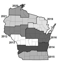
2012 - ongoing
The Wisconsin Department of Natural Resources Division of Forestry converted its aerial photography project to digital (versus film) collection in 2013. The division still generates print products for DNR Forestry staff and partners (prints available for purchase). These photos are 1:15,840 scale, stereoscopic, color infrared, fall coverage. The digital imagery is 18 inches ground resolution. Digital county mosaics are available in color infra-red (4-band) and natural color. Between six to twelve counties are completed every year.
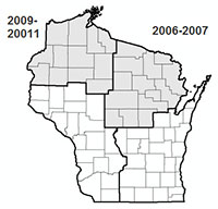
2006-2011
The Division of Forestry moved to fall collection of color infrared imagery in 2006. These photos are 1:15840 scale, stereoscopic, color infrared, fall coverage.
In 2006, the Division of Forestry started scanning the film to provide digital imagery (12 inch ground resolution). Because the film was scanned to create the digital product, digital county mosaics are available in color infra-red tones but not as 4-band imagery. Approximately one-quarter of the state was acquired every two years.
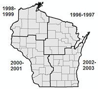
1991-2003
The Division of Forestry began contracting its own flights in 1991 in order to obtain 1:15,840 scale imagery preferred by forest managers. These photos are 1:15,840 scale, stereoscopic coverage, black and white infrared, summer coverage. Approximately one-quarter of the state was acquired every two years.
Aerial photos for 1978-79
In the late 1970s, Forestry collected imagery for the entire state in cooperation with the Wisconsin Department of Transportation (WisDOT). This imagery was 1:20,000, stereoscopic, black and white infrared, summer coverage. To purchase photos, contact the WisDOT at:
WISDOT
Room 5B
3502 Kinsman Blvd
Madison WI 53704
Phone: 608-246-5392
Fax: 608-246-4669
Email: DOTAerialImageryRequest@dot.wi.gov


